Home
>
Mountain View Walking Tours
Mountain View, California
Historic Homes Walking Tour 3
This is a walking tour of the historic Mountain View districts now
known as Waverly Park and Cuesta Park.
Length:
The entire walking tour, round trip, is 3.6
miles long and should take
about an hour and ten
minutes, not including time spent to stop and look.
Map:
Click here for a map
showing the route of the entire tour
with the letters on the map corresponding to those on this page.
Special Conditions:
Parts of this tour travel along streets not having any sidewalks.
As this neighborhood is very quiet, this really shouldn't be an
impediment for you, but if you think it is, you might try the tour
on your bike instead. If you do, you can easily
reach the tour via the Stevens Creek Trail, by exiting it
at Sleeper Avenue, which places you right at the first stop on the
tour. Of course walkers can get there in the same way. If you are on
the park, at the end of the tour there is an add on house found in
Shoreline Park.
Start at ...
A. 992 Sleeper Avenue
map it
corner of Sleeper and Franklin
- huge
- two-story
- visible rafters typical of this style
- multi-pane windows
Next: Walk south on Franklin, turn left on Diericx and continue
southeast for about five blocks in total
to reach ...
|

|
B. 2715 Diericx Drive
map it
near Diericx and Levin
- large
- red tile roof
- wrought iron decoration
- balconies
- varied windows
- arched doorways
Originally owned by:
Frank and Mamie Levin Huff.
Schools are named after both families.
He was principal of an elementary school and city postmaster.
This house was originally located at the end of Levin Avenue,
near Stevens Creek.
Next: Walk north on Diericx, turn left
on Levin Ave, walk six blocks and turn
right on St. Giles Lane
to reach ...
|

|
C. 2682 Saint Giles Lane
map it
at the end of the Saint Giles cul-de-sac off Levin
- multiple gables
- visible roof supports
- elaborate front porch piers
Originally owned by: Charles Bernard Escolle and family, fruit growers
from Monterey.
Next: Walk back to Levin, turn back left, walk one
block to Sun-Mor Avenue, turn left, walk north two
blocks, turn left on Eunice and walk two blocks
to reach ...
|
|
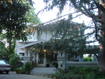
D. 655 Eunice Avenue
map it
near Eunice and Cooper Park
- large frame
- rustic
- high roofline
- many gables and windows
Originally: a speakeasy, distillery, gaming room, greyhound track and
bordello during the 1920s and early '30s. The club finally closed in
1937.
Next: Continue west three blocks on Eunice to Carol Ave, turn north
, turn right on Sleeper and walk half a block
to reach ...
|
|
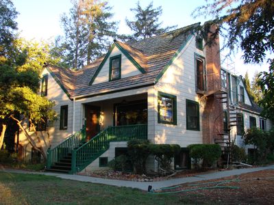
E. 462 Sleeper Avenue
map it
near Sleeper and Sunnyview
- two-story
- gable roof
- large porch
- one of the only remaining farmhouses south of El Camino Real
Next: Turn around and proceed west on Sleeper to Grant Road, turn
left and walk half a block
to reach ...
|
|
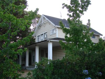
G. 2221 Grant Road
map it
near Sleeper and Grant Road
- elaborate
- hipped roofs
- bay windows
- hexagonal porch
Originally owned by: the sons of Charles H. Mercer, early San
Francisco candy manufacturer.
Next: Walk north on Grant Road to Cuesta Drive. Cross Grant Road
and continue northeast on Grant Road. Shortly you will reach
the sidewalk of an unconnected side street. This is Tyler Park Way.
Walk north on this street
to reach ...
|
|
|
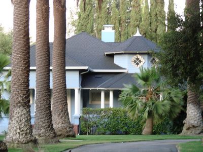
G. 1531 Tyler Park Way
map it
at the south end of Tyler Park near Grant
Originally owned by:
Next: Walk north on Tyler Park and turn left on Barbara.
Walk west four blocks and turn left on Leona Lane.
Follow this curving lane to Begen Ave and turn left to reach
Cuesta Drive. Turn left on Cuesta and walk to reach Miramonte.
At Miramonte, cross Cuesta and walk two blocks
to reach ...
|

|
H. 1855 Miramonte Avenue
map it
near Miramonte and Rose Ave
- elaborate
- high gables
- two story bay window
- half timbering
Originally owned by: William P. and Nellie Swall Wright, until 1948. He was a
founder of the First National Bank of Mountain View and a real estate
broker. The house was originally surrounded by orchards.
This is the end of the tour. Hope you enjoyed it!
|

|
To get back to the start of the tour,
walk north again to reach Cuesta Drive. Turn right and continue on
it to Grant Road. Cross Grant and turn right to reach Sleeper Ave.
Turn left on Sleeper and follow it east to its end.
If you're on your bike you might like to see the bonus stop below, the
Rengstorff House. To get there, get on the Stevens Creek Trail and
head north until reaching Shoreline Park. Once there, go through the
gate and follow the main road into the park to reach the house just
before the sailing lake. This is a trip of about 6 miles.
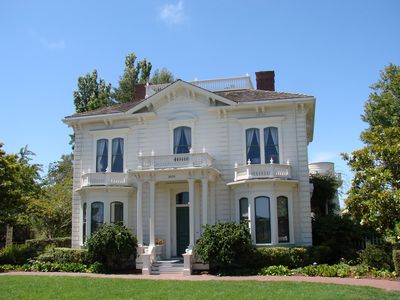
3070 North Shoreline Boulevard
in Shoreline Park near the sailing lake
- probably the oldest structure in Mountain View
- symmetrical two-story
- hip roof
- central gable
- five-panel front door
- many tall windows
- strong vertical lines
- pillared entryway
- operated by city as a museum
- tourable interior
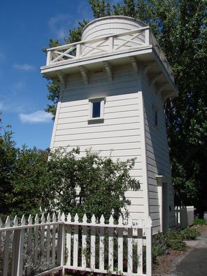
- accompanying tank house
- has its own
website
Originally owned by:
Henry Rengstorff,
a German lured to California
by the gold rush and
Mountain View pioneer who
operated a wharf and boating operation near where the house stands
today. He married another German, Christine Hassler, and their seven
children also lived in the house, which was
moved from what is now the Shoreline business park
to the current location in 1994.
This is the real end of the tour. Hope you enjoyed it!
|
|
All photos by ET. Thanks so much, ET!
August 31, 2009
If you enjoyed this tour, you may also like to try the
Original Historic Homes Walking Tour
and
Historic Homes Walking Tour 2.
spotlightongames.com